Discover Grand Falls, Arizona
Grand Falls is one of Arizona's most surprising natural sights — a genuine waterfall, taller than Niagara Falls, hidden in the high desert on Navajo Nation land northeast of Flagstaff. Unlike most famous waterfalls, Grand Falls doesn't flow year-round. It's an intermittent, seasonal spectacle, running heaviest during spring snowmelt and after summer monsoon storms, and often reduced to a dry, silent canyon the rest of the year.
When it does run, the Little Colorado River pours over a basalt lava dam in a thick, churning curtain of chocolate-brown water, earning the falls their popular nickname, "Chocolate Falls." The unpredictability is part of the appeal: locals and photographers alike watch snowpack reports and storm forecasts for a chance to catch the falls at their most dramatic, since no two visits — wet or dry — ever look quite the same.
What Is Grand Falls?
Grand Falls is a waterfall on the Little Colorado River, formed not by a river cutting downward through rock over millions of years, but by an ancient lava flow that dammed the river's original channel. The river now spills over that basalt dam in a dramatic drop, carving a churning cataract into the surrounding sandstone and shale canyon.
The falls are located entirely within the Navajo Nation, roughly 30 miles northeast of Flagstaff, in a remote, undeveloped stretch of high desert. There's no visitor center, no paved overlook, and no entrance gate — just a dirt access road leading to an open canyon rim where the falls come into view.
What makes Grand Falls genuinely unusual is its intermittent nature. Many visitors expect a waterfall to be a permanent, ever-flowing feature, but Grand Falls is fundamentally seasonal — dependent entirely on how much water the Little Colorado River is carrying at any given time, which varies dramatically throughout the year and from year to year.
Where Is Grand Falls Located?
Grand Falls sits on the Little Colorado River within the Navajo Nation, roughly 30 miles northeast of Flagstaff, Arizona. The site is reached via Highway 89 north out of Flagstaff, then east on Indian Route 70 (also signed as Grand Falls Road), a mix of paved and unpaved road leading directly to the canyon rim overlooking the falls.
| Starting Point | Approx. Driving Time |
|---|
| Flagstaff | 45–60 minutes |
| Sedona | 1 hour 30 minutes |
| Winslow | 1 hour |
| Grand Canyon South Rim | 2 hours |
| Page | 2 hours 30 minutes |
The final stretch of Grand Falls Road is unpaved dirt, graded but occasionally rutted or washboarded, and can become difficult or impassable after heavy rain. Checking current road conditions before setting out is always worthwhile, especially during monsoon season when the same storms that fill the falls can also turn the access road to mud.
Is Grand Falls Taller Than Niagara Falls?
Yes — by height alone, Grand Falls actually surpasses Niagara Falls. Grand Falls drops roughly 185 feet, compared to Niagara's American Falls at about 167 feet and Horseshoe Falls at around 176 feet. That single fact is the source of Grand Falls' popular "Arizona's Niagara" nickname, and it genuinely surprises most first-time visitors.
The comparison, however, only goes so far. Niagara Falls carries an enormous, continuous volume of water — hundreds of thousands of gallons per second, year-round. Grand Falls, by contrast, is intermittent and carries a small fraction of that volume even during its heaviest flows. The nickname is about height and drama, not water volume, and visitors expecting a Niagara-scale river should adjust expectations accordingly — Grand Falls' power lies in its unpredictability and remote desert setting, not its constant roar.
When Does Grand Falls Flow?
Grand Falls' flow is genuinely unpredictable, but it follows two general seasonal patterns tied to the Little Colorado River's watershed far upstream in the White Mountains and around Flagstaff's San Francisco Peaks.
Spring Snowmelt (March–April)
As winter snowpack melts across the river's high-elevation headwaters, runoff feeds into the Little Colorado River and can produce a strong, sustained flow at Grand Falls lasting days or weeks, depending on how much snow accumulated that winter.
Summer Monsoon (July–September)
Arizona's summer monsoon storms can dump intense, localized rainfall across the watershed, sending flash flood pulses down the Little Colorado River that reach Grand Falls within hours. These flows tend to be shorter and more dramatic — sudden, powerful, and often gone again within a day or two.
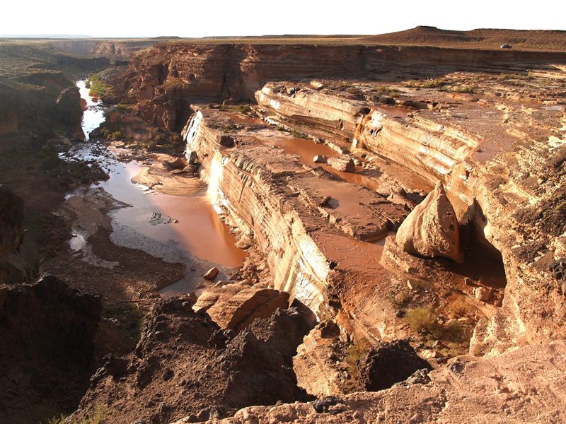
Outside these windows, the riverbed at Grand Falls is frequently dry or reduced to isolated, muddy pools, with the layered sandstone and basalt canyon walls standing exposed. There's no reliable published schedule for when the falls will run — checking recent weather, snowpack reports, and traveler reports before making the trip is the only real way to improve your odds.
Why Is Grand Falls Brown?
The Little Colorado River's characteristic chocolate-brown color comes from heavy sediment loads picked up as it flows through the erodible badlands of the Painted Desert upstream. Loose clay, silt, and fine sand wash into the river with every storm, coloring the water a thick, muddy brown that only intensifies during high-flow periods — precisely when Grand Falls is at its most dramatic.
That sediment load is also why the falls earned their informal nickname, "Chocolate Falls," among locals — a nod to both the color and the thick, almost syrupy texture of the water during peak flow. It's a striking, unusual sight for a waterfall, and part of what makes Grand Falls feel so different from the clear, blue-white cascades most visitors picture.
Geology of Grand Falls
Grand Falls exists because of volcanic activity, not ordinary river erosion. Long ago, a lava flow originating from a nearby volcanic vent in the San Francisco Volcanic Field spread across the landscape and poured directly into the existing channel of the Little Colorado River, forming a natural dam of solid basalt across the riverbed.
Rather than simply pooling behind that dam, the river eventually found a new path, cutting a channel around and over the resistant basalt, plunging down its edge in the process. That drop is Grand Falls itself — a waterfall created by volcanic rock rerouting a river, rather than a river slowly carving its own descent through progressively softer stone.
The canyon surrounding the falls exposes layers of sedimentary rock beneath the basalt cap, including sandstone and shale laid down long before the volcanic flow arrived. That contrast — dark, resistant volcanic rock capping older, softer sedimentary layers — is a recurring theme across Northern Arizona's landscape, visible in a different form at Sunset Crater and throughout the wider San Francisco Volcanic Field. For more on the deeper rock record behind this region, see our Arizona Geology → and Colorado Plateau → guides.
Indigenous Significance
Grand Falls lies entirely within the Navajo Nation, and the Little Colorado River holds deep, ongoing significance for the Navajo people, as it does for other Indigenous nations connected to this stretch of the Colorado Plateau. This landscape has never been empty or undiscovered — it has been known, traveled, and valued by Native communities for far longer than it has carried the English name "Grand Falls."
Visitors should approach the site with the same respect they'd bring to any culturally significant landscape: staying on established roads and viewpoints, packing out all trash, and remembering that this remote, dramatic canyon is home ground for the Navajo Nation, not simply a backdrop for photography. For more on the Navajo Nation and its connection to the surrounding region, see our Navajo Nation → guide.
Visiting Grand Falls Today
Grand Falls remains a largely undeveloped natural site. There's no visitor center, no paved overlook platform, and no formal entrance — visitors simply drive to the canyon rim along Grand Falls Road and walk a short distance to unmarked viewpoints along the edge. Multiple informal pullouts along the rim offer different vantage points looking down into the canyon and across the falls.
Because the site is undeveloped, there are no restrooms, no food service, and no reliable cell service in the immediate area — visitors should come prepared with water, sun protection, and a full tank of gas, treating the trip more like a backcountry excursion than a typical roadside attraction.
Getting There and Road Conditions
From Flagstaff, the route to Grand Falls follows Highway 89 north, then turns east onto Indian Route 70 (Grand Falls Road). The road transitions from pavement to graded dirt for the final stretch leading to the falls, a surface that's usually manageable in a standard vehicle in dry conditions but can become rutted, muddy, or temporarily impassable after significant rain.
Because the road can deteriorate quickly during monsoon season — the same storms that often bring the falls to life — checking current road conditions before setting out is genuinely important, not just a formality. A high-clearance vehicle is a reasonable precaution even when conditions look fine at the start of the drive.
Permits and Navajo Nation Land
Grand Falls sits entirely within the Navajo Nation, and visitors should treat the site with the same respect and awareness of tribal land status as anywhere else on the reservation. A Navajo Nation recreational permit may be required depending on current tribal regulations, so checking current permit requirements directly with the Navajo Nation before visiting is the responsible approach, rather than assuming free, unrestricted access.
Staying on established roads and viewpoints, packing out all trash, and being mindful that this is home to Navajo communities — not simply a scenic backdrop — all matter here, just as they do throughout the wider Navajo Nation.
Best Time to Visit
Spring
Spring offers the most reliable chance of seeing the falls actively flowing, thanks to snowmelt runoff, alongside comfortable daytime temperatures for the drive and viewpoint walk.
Summer
Summer brings intense heat and the chance of a dramatic monsoon-driven flow, but also flash-flood risk on both the river and the access road — check forecasts carefully before heading out during storm season.
Fall
Fall typically brings drier conditions and a lower chance of active flow, but pleasant temperatures for exploring the canyon rim and taking in the geology even when the falls themselves are quiet.
Winter
Winter is generally the driest period at the falls themselves, though cold temperatures and occasional snow can make the access road more challenging.
There's no single best season to guarantee an active waterfall — timing a visit around recent snowmelt reports or a recent monsoon storm is more reliable than picking a calendar season alone.
Wildlife and Plants
The high-desert terrain surrounding Grand Falls supports typical Colorado Plateau wildlife, including coyotes, jackrabbits, ravens, and a variety of reptiles adapted to the area's heat and limited water. Hawks and other raptors are frequently seen riding thermals above the canyon, taking advantage of the open terrain and updrafts along the cliff edges.
Vegetation here is sparse but resilient — scattered junipers, desert grasses, and hardy high-desert shrubs typical of this stretch of the Navajo Nation, adapted to long dry spells punctuated by the same seasonal water pulses that feed the falls themselves. For more on the animals found across the wider region, see our Arizona Wildlife → guide.
Safety Considerations
Grand Falls is an undeveloped natural site with no guardrails, fencing, or formal barriers along the canyon rim. Cliff edges near the falls can be unstable, and the drop to the canyon floor is significant — visitors should stay well back from the edge and supervise children closely at all times.
Never enter the river near the falls. Strong currents, unstable and unpredictable footing, and heavy sediment make swimming or wading genuinely dangerous, even when the flow looks modest from above.
Cell service is unreliable to nonexistent in the immediate area, so it's worth telling someone your plans before heading out, carrying extra water, and treating the trip with the same preparation you'd bring to any remote backcountry destination — because that's effectively what Grand Falls is.
Photography Tips
Grand Falls is most dramatic — and most worth photographing — during an active flow, when the thick, chocolate-brown water churns over the basalt drop in a way no still photo fully captures on a first viewing. Morning and late-afternoon light bring out the warm tones in the surrounding canyon walls, while midday sun tends to flatten the scene's contrast and color.
A wide-angle lens helps capture the full scale of the canyon and falls together from the rim viewpoints, while a longer lens can isolate the churning water and layered rock texture at the drop itself. Because conditions and water levels change so quickly here, it's worth taking a range of shots from multiple viewpoints along the rim rather than settling for the first vantage point you reach.
Nearby Attractions
Grand Falls pairs naturally with several other Northern Arizona destinations within a short drive.
Flagstaff
The high-country hub for exploring Northern Arizona, about 45–60 minutes away.
READ GUIDE →Meteor Crater
A nearly one-mile-wide meteorite impact crater east of Flagstaff.
READ GUIDE →Painted Desert
Vividly banded badlands stretching across northeastern Arizona.
READ GUIDE →Sunset Crater Volcano
A young cinder cone volcano tied to the same volcanic field.
READ GUIDE →Navajo Nation
The largest Native American reservation in the United States.
READ GUIDE →Wupatki National Monument
Ancestral Puebloan pueblos on the open Colorado Plateau.
READ GUIDE →
Frequently Asked Questions
Where is Grand Falls located?
Grand Falls sits on the Little Colorado River on Navajo Nation land, roughly 30 miles northeast of Flagstaff, Arizona.
Is Grand Falls taller than Niagara Falls?
Yes — Grand Falls drops about 185 feet, roughly 35 feet taller than Niagara Falls, though it carries far less water and flows only seasonally.
Does Grand Falls flow year-round?
No. Grand Falls is intermittent, typically flowing during spring snowmelt (March–April) and after summer monsoon storms (July–September); for much of the year the riverbed is dry or reduced to shallow pools.
Why is Grand Falls brown?
The Little Colorado River carries heavy sediment loads from the Painted Desert badlands upstream, giving the water its characteristic chocolate-brown color, especially during high flows.
Do I need a permit to visit Grand Falls?
Grand Falls sits on Navajo Nation land; a Navajo Nation recreational permit may be required depending on current tribal regulations, so check current requirements before visiting.
How do I get to Grand Falls?
From Flagstaff, take Highway 89 north, then follow Indian Route 70 (Grand Falls Road) east; the final stretch is unpaved dirt road.
Is Grand Falls worth visiting when dry?
Even dry, the canyon and layered cliff formations are worth seeing, though the site's main draw — the waterfall itself — is only visible during active flow periods.
Can you swim at Grand Falls?
Swimming is not recommended; the river carries heavy sediment, unpredictable currents, and unstable footing near the falls.
Why Visit Grand Falls?
Grand Falls offers something genuinely rare in Arizona — a real, dramatic waterfall taller than Niagara Falls, set within a remote volcanic canyon on Navajo Nation land. Its unpredictable, seasonal flow makes every visit a bit of a gamble, but that same unpredictability is exactly what makes catching the falls in full flow feel like a real discovery rather than a scheduled tourist stop. Paired with nearby Flagstaff, Meteor Crater, or the Painted Desert, Grand Falls adds a genuinely unusual, off-the-beaten-path chapter to any Northern Arizona itinerary.
Continue Exploring Arizona's Scenic Wonders
Grand Falls is one of Northern Arizona's most surprising natural sights, and it pairs naturally with a wider exploration of the region's volcanic and geological landscapes. If you'd like to experience Northern Arizona without the stress of planning, Grand Canyon Journeys offers private luxury tours featuring expert local guides, scenic routes, and personalized itineraries throughout the region.