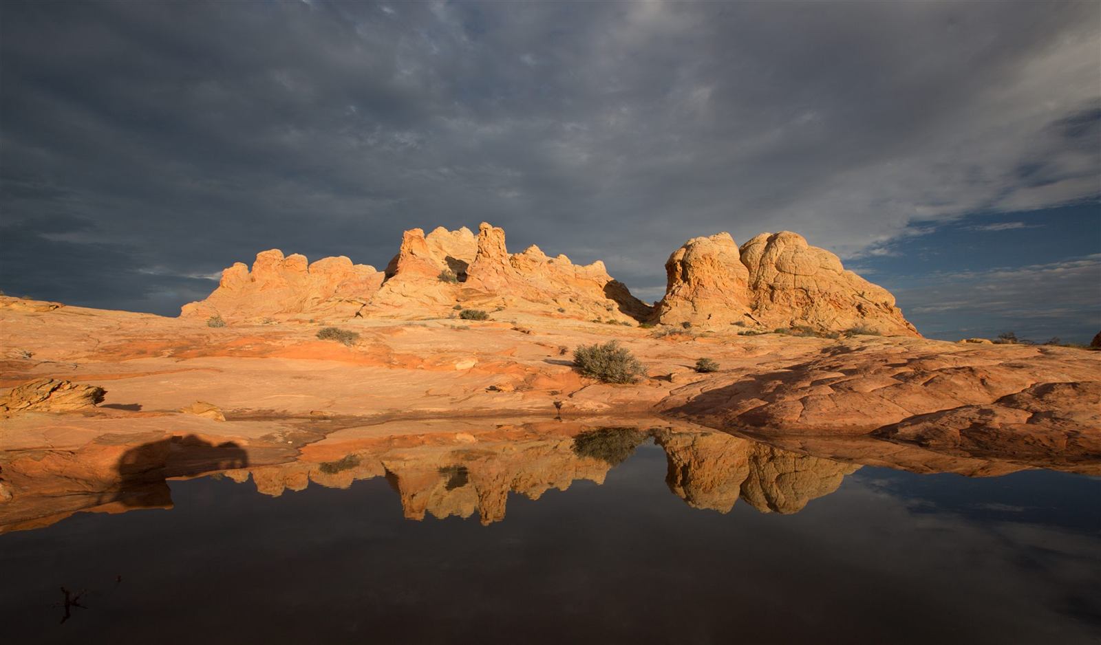
Vermilion Cliffs National Monument
Vermilion Cliffs National Monument is one of Northern Arizona's most dramatic and remote landscapes — a sweep of colorful sandstone cliffs, plateaus, and slot canyons straddling the Arizona-Utah border near Page. Within its boundaries lie some of the Southwest's most photographed formations, including The Wave, White Pocket, Paria Canyon, and Buckskin Gulch, alongside vital nesting and roosting habitat for the endangered California condor.
This is genuine backcountry: services are limited, roads are often unpaved and demanding, and cell service is unreliable across much of the monument. Permits are required to access certain areas, such as Coyote Buttes North (home to The Wave) and Coyote Buttes South, and for overnight trips in Paria Canyon — but not for every part of the monument. Roadside viewing along Highway 89A and destinations like White Pocket require no permit at all, though they demand careful preparation of their own. This guide covers what the monument actually offers, how access and permits work, and how to visit safely and respectfully.
What Is Vermilion Cliffs National Monument?
Vermilion Cliffs National Monument was designated in 2000 and is managed by the Bureau of Land Management (BLM) rather than the National Park Service. That distinction matters: unlike a developed national park with paved scenic drives, staffed entrance stations, and extensive visitor infrastructure, Vermilion Cliffs is largely undeveloped wilderness. There are no paved roads through most of the monument, no shuttle system, and only minimal facilities.
The monument spans roughly 280,000 acres on the Colorado Plateau, encompassing the towering escarpment of the Vermilion Cliffs themselves, the elevated Paria Plateau, deep slot canyons, and isolated sandstone formations sculpted into swirling, otherworldly shapes. Elevations range from about 3,100 to 7,100 feet, producing considerable variation in climate and terrain across the monument's area.
What unites this landscape is its emphasis on preservation over development. The BLM manages Vermilion Cliffs specifically to protect its geologic, scenic, and ecological character, which means visitors trade convenience for a genuinely wild, largely unmodified experience — one that rewards preparation and respect far more than a typical national park visit does.
Where Are the Vermilion Cliffs?
Vermilion Cliffs National Monument sits in the far northern reaches of Arizona, hugging the Arizona-Utah border between the towns of Page and Kanab. U.S. Highway 89 and U.S. Highway 89A both pass through or near the monument, with 89A running directly beneath the cliffs themselves through Marble Canyon and House Rock Valley — one of the most scenic drives in the region even without leaving pavement.
| Starting Point | General Driving Context |
|---|
| Page, AZ | Closest major town; roughly 30–45 minutes to monument viewpoints |
| Kanab, UT | Closest town from the west; similar range of driving times |
| Flagstaff | Roughly 2 to 2.5 hours depending on route and destination |
| Grand Canyon South Rim | Roughly 2 to 2.5 hours via Highway 89 and 89A |
| Grand Canyon North Rim | Roughly 1.5 to 2 hours via House Rock Valley Road |
These figures are general guidance only. Actual travel times depend heavily on which specific destination within the monument you're visiting, current road conditions, and weather — a short distance on a map can mean a long, slow drive on deep sand or a rutted, rain-soaked track.
Geology of Vermilion Cliffs
The cliffs and formations of this monument are built primarily from Navajo Sandstone, a rock layer formed from a vast field of ancient sand dunes that covered much of this region during the Jurassic Period, roughly 190 million years ago. Wind-driven dunes, migrating and shifting over enormous spans of time, left behind the sweeping, curved internal patterns known as cross-bedding — layered, diagonal lines visible throughout the sandstone today that record the direction and angle of long-vanished dune faces.
The rock's vivid color comes primarily from iron oxide, the same basic mineral process responsible for rust, staining the sandstone in bands of red, orange, pink, and, where iron content is lower, pale white or cream. Variations in mineral content and groundwater history from one layer to the next produce the dramatic striping visible across the cliff faces and, in an even more concentrated form, in formations like The Wave.
Millions of years after these dunes solidified into stone, the broad uplift of the Colorado Plateau raised this entire region substantially, exposing the Navajo Sandstone to erosion for the first time since it had been buried under later rock layers. Wind and water have worked on that exposed sandstone ever since, carving the towering cliff faces, rounded domes, narrow ridges, and deep slot canyons that define the monument's terrain today.
At The Wave and White Pocket, that erosional process has produced particularly unusual results. Differential erosion — where slightly harder and softer bands of sandstone wear away at different rates — combined with the original cross-bedded dune patterns to create the swirling, undulating rock surfaces these two locations are famous for. White Pocket's surface, often described as looking like solidified "brain rock," reflects an especially complex mix of cross-bedding, later horizontal deposits, and long-term erosion, distinct even from the swirled patterns at The Wave a short distance away. For more on the deeper rock record connecting this area to the rest of the region, see our Arizona Geology → and Colorado Plateau → guides.
Major Places to See
The Wave and Coyote Buttes North
The Wave is the monument's most famous formation, located within the Coyote Buttes North permit area — a swirling basin of striped, cross-bedded sandstone that has become one of the most photographed rock formations in the world. Reaching it requires a strenuous, unmarked hike of several miles across open desert and slickrock, with genuine route-finding required rather than a maintained trail. Because Coyote Buttes North permits are tightly limited to protect the formation and manage visitor safety, daily access is capped and demand far outweighs supply. Visitors should also plan carefully around heat and sun exposure, since there is no shade anywhere along the route.
Coyote Buttes South
South of The Wave, Coyote Buttes South offers its own collection of colorful sandstone formations under a separate permit system, including popular areas known as Paw Hole and Cottonwood Cove. Access roads here are notably rough and sandy, generally requiring high-clearance, four-wheel-drive vehicles. While less internationally famous than The Wave, Coyote Buttes South rewards visitors with striking formations of its own and, on many days, considerably lighter visitor traffic.
White Pocket
White Pocket is a striking landscape of red-and-white banded sandstone, its surface twisted into unusual, bulbous "brain rock" formations unlike anywhere else in the monument. Unlike Coyote Buttes North and South, White Pocket requires no permit — but that doesn't make it an easy destination. The approach roads are remote, deep sand is common, and a capable high-clearance, four-wheel-drive vehicle (or a guided tour) is essentially required; there are no dependable services anywhere nearby if you get stuck.
Paria Canyon and Buckskin Gulch
Paria Canyon and its tributary Buckskin Gulch form one of the longest slot canyon systems in the Southwest, offering everything from long-distance backpacking trips to shorter day hikes near the trailheads. Multi-day trips through Paria Canyon require an overnight permit and careful planning, since these narrow, deep canyons offer very few escape routes if flash flooding occurs. Even shorter day hikes demand real caution — checking weather and flash-flood forecasts before entering is essential, not optional, anywhere in this canyon system.
Permits and Access
Permit requirements at Vermilion Cliffs vary considerably by destination, and it's worth understanding each one separately rather than assuming a single permit covers the whole monument.
Coyote Buttes North (The Wave) requires a permit obtained through a lottery system due to overwhelming demand, with daily visitor numbers tightly capped to protect the formation. Coyote Buttes South requires its own, separate permit, generally easier to obtain than Coyote Buttes North but still limited. Paria Canyon overnight trips require a backcountry permit of their own, distinct from either Coyote Buttes permit. Day hikes into Paria Canyon and Buckskin Gulch that don't involve overnight camping typically have different, generally simpler day-use requirements.
Areas like White Pocket and roadside viewing along Highway 89A do not use The Wave's lottery system at all and require no permit — a common point of confusion for first-time visitors who assume every part of the monument is equally restricted.
The clearest way to understand this system: a permit for one area does not automatically provide access to another area. A Coyote Buttes South permit does not grant entry to Coyote Buttes North, and neither covers overnight travel in Paria Canyon. Because permit systems, quotas, and processes are updated by the Bureau of Land Management from time to time, check current details, availability, and application procedures directly at the official BLM Vermilion Cliffs National Monument page and Recreation.gov before planning your trip.
Roads and Four-Wheel-Drive Requirements
Not every part of Vermilion Cliffs requires off-road driving. Simply viewing the cliffs from Highway 89A is entirely doable in any standard vehicle, since the road itself is fully paved and runs directly beneath the escarpment. Reaching remote destinations within the monument, however, is a different matter entirely.
Beyond the pavement, most monument access roads are graded dirt at best, and conditions shift quickly and unpredictably. Deep, soft sand is common across much of the Paria Plateau, capable of stranding vehicles without adequate clearance or tires. Rain transforms these same roads into slick, axle-deep mud almost immediately, and washboard surfaces — rippled, jarring ridges from repeated vehicle travel — are a near-constant feature of the longer approach roads.
Reaching destinations such as White Pocket or Coyote Buttes South generally requires a genuine high-clearance, four-wheel-drive vehicle — all-wheel-drive crossovers, despite the name, typically lack the clearance and low-range gearing needed for deep sand and are not a reliable substitute. Carrying a full-size spare tire, extra water, and basic recovery equipment is strongly recommended, since cellular service is unreliable to nonexistent across most of this backcountry, and help can be hours away if something goes wrong.
Best Time to Visit
Spring
Spring brings comfortable temperatures for hiking, along with considerable wind at times. It's also one of the most popular seasons for permit demand, particularly for The Wave.
Summer
Summer brings extreme heat with little to no shade across most of the monument's exposed sandstone terrain, along with monsoon season's genuine flash-flood danger in slot canyons and washes.
Fall
Fall generally offers pleasant temperatures and favorable conditions for photography, with cooler days than summer and typically calmer weather than the monsoon season.
Winter
Winter brings cold temperatures, occasional snow at higher elevations, muddy and sometimes impassable roads after storms, and considerably shorter daylight hours to plan around.
No single season is universally best across the entire monument — conditions vary significantly by elevation, by specific destination, and from year to year, so check current forecasts and road conditions directly before any trip regardless of season.
Hiking and Wilderness Safety
Vermilion Cliffs National Monument has few marked trails, and destinations like The Wave, White Pocket, and Coyote Buttes South all require genuine route-finding and navigation skills across open, exposed sandstone rather than following a defined path. Bring reliable offline maps and know how to use them, since cellular service and GPS data connections are unreliable to nonexistent across most of the backcountry.
Heat is a serious, ongoing hazard here — carry considerably more water than you think you'll need, since there is little to no shade across most of the monument's open terrain. Set conservative turnaround times before you start hiking and stick to them regardless of how the day is going, and always tell someone your specific route and expected return time before heading into the backcountry.
Never enter a slot canyon when significant rain is forecast anywhere in the surrounding drainage.
Flash floods in canyons like Paria Canyon and Buckskin Gulch can originate from storms many miles away and arrive with little to no warning, and these narrow canyons often offer very few, if any, escape routes once you're inside. Check current weather and flash-flood forecasts before every entry, and be willing to postpone or turn back entirely if conditions look uncertain.
California Condors and Wildlife
Vermilion Cliffs is one of the most important sites in the ongoing recovery of the California condor, a critically endangered species that came perilously close to extinction in the 20th century. The cliffs here provide vital roosting and nesting habitat, and the monument includes a dedicated condor-viewing site where visitors have a genuine chance of spotting these enormous birds — among the largest flying land birds in North America — riding thermals along the escarpment.
Beyond condors, golden eagles and ravens are commonly seen overhead, while coyotes, mule deer, and numerous reptile species move through the monument's high-desert terrain. Hardy desert plants, adapted to minimal water and intense sun, form the visible backbone of this ecosystem, but much of its real biological foundation lies at ground level: biological soil crust, a fragile, living layer of cyanobacteria, lichens, and moss that stabilizes desert soil and prevents erosion.
This crust can take decades to form and is easily destroyed by a single footstep or tire track, so visitors should stay on durable surfaces like slickrock, established trails, or wash bottoms whenever possible, and avoid walking or driving across the dark, crusted soil found throughout the monument. For more on the animals found across the wider region, see our Arizona Wildlife → guide.
Indigenous and Cultural History
Indigenous peoples have moved through and lived in this region for thousands of years, long before it carried the name Vermilion Cliffs or any monument boundary. Ancestral travel routes crossed this landscape connecting distant communities, and archaeological sites — including small pueblos and rock imagery — remain scattered throughout the monument today, physical evidence of a long, continuous human presence rather than an empty wilderness.
These sites and the objects associated with them are legally protected, and their protection depends significantly on how visitors behave. Do not touch rock imagery, since oils from skin can accelerate the deterioration of images that have survived for centuries. Do not move or remove artifacts of any kind, even small pottery fragments that might seem insignificant. Do not share specific coordinates of sensitive archaeological sites publicly, since exposure can lead directly to looting or vandalism. And avoid describing this landscape as historically empty — it has never been that, and treating it that way erases a long, ongoing Indigenous relationship with this land.
Photography Tips
Sunrise and sunset light bring out the deepest reds and richest contrast in the monument's sandstone, particularly at The Wave and White Pocket, where low-angle light rakes across the swirling rock texture and reveals depth that flat midday light simply doesn't capture. A wide-angle lens suits the monument's sweeping landscapes well, while a telephoto lens can isolate smaller details in the cliff faces and striped formations.
Inside slot canyons like Buckskin Gulch, reflected light bouncing between narrow sandstone walls can produce striking warm tones even without direct sun reaching the canyon floor — worth watching for rather than only shooting during golden hour. Dust and wind are near-constant considerations for camera gear across this exposed terrain, so plan protection accordingly, and winter visits bring their own cold-weather considerations for batteries and equipment.
Whatever shot you're chasing, stay on durable surfaces and established routes to capture it — this landscape's fragile sandstone and biological soil crust are not worth damaging for a photograph, and off-route travel purely to reproduce someone else's image is never worth the cost to the place itself.
Nearby Attractions
Vermilion Cliffs sits within a wider network of significant Northern Arizona landscapes and makes a natural addition to a broader regional itinerary.
Page, Arizona
The closest town and a natural base for exploring the monument.
READ GUIDE →Lake Powell
A vast reservoir carved through red-rock canyon country nearby.
READ GUIDE →Horseshoe Bend
The Colorado River's dramatic curve, a short drive from Page.
READ GUIDE →Glen Canyon
The canyon system behind Lake Powell and Glen Canyon Dam.
READ GUIDE →Grand Canyon National Park
Both rims lie within a few hours of the monument.
READ GUIDE →Colorado Plateau
The vast geological province underlying this entire region.
READ GUIDE →
Marble Canyon and Lees Ferry, both just off Highway 89A near the monument, add historic river-crossing and rafting-launch context to any Vermilion Cliffs visit.
Frequently Asked Questions
Where are the Vermilion Cliffs?
Vermilion Cliffs National Monument sits in far northern Arizona along the Arizona-Utah border, between the towns of Page and Kanab, along U.S. Highways 89 and 89A.
Is The Wave inside Vermilion Cliffs National Monument?
Yes. The Wave is located within Coyote Buttes North, a permit area inside Vermilion Cliffs National Monument.
Do you need a permit to visit?
It depends on where you're going. Roadside viewing from Highway 89A requires no permit, but Coyote Buttes North, Coyote Buttes South, and overnight trips in Paria Canyon each require a separate permit.
Can you visit without winning The Wave lottery?
Yes. Much of Vermilion Cliffs National Monument, including roadside viewpoints and areas like White Pocket, does not use The Wave's Coyote Buttes North lottery system.
Does White Pocket require a permit?
No. White Pocket does not require a permit, though it does require a difficult high-clearance, four-wheel-drive approach and has no dependable services.
Do you need four-wheel drive?
For roadside viewing along paved highways, no. For destinations like White Pocket or Coyote Buttes South, yes — deep sand and rough, ungraded roads generally require true four-wheel drive, not just all-wheel drive.
Is there cell service?
Cellular service is unreliable to nonexistent across most of the monument's backcountry, so download offline maps and inform someone of your plans before heading out.
Are dogs allowed?
Policies vary by area and permit type; check current Bureau of Land Management guidance for the specific zone you plan to visit before bringing a pet.
Can you camp in the monument?
Dispersed and designated camping options exist in parts of the monument; check current Bureau of Land Management and Recreation.gov guidance for permitted areas and any required permits.
What is the best time of year to visit?
Spring and fall generally offer the most comfortable temperatures, though conditions vary considerably by season and by which part of the monument you're visiting.
Why Visit Vermilion Cliffs?
Vermilion Cliffs National Monument offers some of the most extraordinary geology anywhere on the Colorado Plateau — colorful, cross-bedded sandstone sculpted into a genuinely remote wilderness of cliffs, plateaus, and slot canyons. The Wave and White Pocket rank among the most striking rock formations on Earth, Paria Canyon and Buckskin Gulch offer serious slot-canyon adventure, and the monument's condor conservation program connects visitors to one of North America's great wildlife recovery stories. Combined with its proximity to Page and Marble Canyon, Vermilion Cliffs rewards travelers willing to prepare — but this landscape asks for genuine preparation and respect in return, not a casual drive-through.
Explore More of Northern Arizona
Vermilion Cliffs National Monument reveals some of the Colorado Plateau's most remarkable sandstone landscapes. Continue planning your journey with guides to Page →, Lake Powell →, and the Grand Canyon →. Grand Canyon Journeys offers private Northern Arizona tours with knowledgeable local guides, comfortable transportation, and personalized itineraries.
Explore Private Arizona Tours
Custom itineraries across Northern Arizona
VIEW ALL TOURS →
Explore Northern Arizona Canyon Country
The Vermilion Cliffs sit in one of the emptiest corners of the state, and the country between there and Page is extraordinary. Our Antelope Canyon and Horseshoe Bend tour explores that landscape with a Navajo guide through the slot canyon and a stop above the Colorado River, traveling privately from Sedona or Flagstaff.
Antelope Canyon & Horseshoe Bend Tour
From $419
VIEW TOUR →